Description
🎯 Elevate your drone mapping game with pinpoint precision and rugged reliability!
- SECURE STABLE PLACEMENT - Corner eyelets anchor targets firmly, preventing movement during flights and enabling multi-session mapping.
- BUILT TO BRAVE THE ELEMENTS - Durable, weatherproof mesh with matte finish reduces glare and withstands field conditions for repeat use.
- PRECISION MAPPING MADE SIMPLE - Standard 24"x24" size ensures consistent scale and reliable post-processing accuracy up to 400 feet altitude.
- SEAMLESS SOFTWARE COMPATIBILITY - Optimized for top photogrammetry platforms like Pix4D, DroneDeploy, Metashape, and more for effortless integration.
- PINPOINT CENTERING WITH ZERO DAMAGE - Innovative center eyelet lets you mark exact GCP centers using survey rods without tearing or wear.
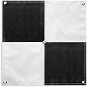
The Sky High Bull's-Eye 24"x24" Drone Ground Control Points (6-pack) are expertly designed aerial targets for low to medium altitude drone mapping up to 400 feet. Featuring a unique center eyelet for exact survey rod placement and corner anchors for stability, these lightweight, weatherproof mesh targets reduce glare and ensure repeatable, high-accuracy data capture. Fully compatible with leading photogrammetry software, they are the go-to solution for professional-grade UAV surveying and mapping.