


Sequoia and Kings Canyon National Parks Map (National Geographic Trails Illustrated Map, 205)
S**S
Useful Map
Good map for planning a sequoia vacation!
A**R
Great Map But Don't Use it for Mileage
I just used this map for a trek across the High Sierra Trail. Its helpful to have, but it does not account for switchbacks, and the mileage is much much more than it claims, in the key.
T**C
Be aware: Disney ownership, copyright dates may not be revision dates
Trails Illustrated maps are no longer published by the National Geographic Society. Rather they are published by a business corporation named "National Geographic Partners", which is 73% owned by The Walt Disney Company. Many of the maps have been reprinted with a 2019 copyright date, including this title, but the cartographic data may not have been updated. I collect maps extensively and own dozens of Trails Illustrated maps, and I have found several titles that were reprinted with a new copyright date, but only minor revisions in the text. It seems that Amazon has caught on to this, and is listing the actual revision date.I compared 2 editions of this map: the first was copyrighted in 1983, "Revised 2011 Minor Updates 2013"; and the second was "Copyright 2019". I could not find a single change in the cartographic data. There were only minor changes in the text, none of it related to information about the area covered by the map.The ISBN cannot be relied on to distinguish editions for maps and atlases, as publishers will often retain the same ISBN even when publishing updated editions.
T**P
Great map!
I usually buy Tom Harrison maps but decided this out due to the reviews. Great overview of the park and a lot of the popular trails are marked. I've been backpacking in the area, but I'm about to take the wife on a weekend trip to see the Sequoias and wanted a good map to take. This map shows all the popular trail and ranger stations. It even details some of the lodges in the area and ranger stations. If I was going on a serious hike though I'd want a little more detail. I believe there are separate maps for the Mineral King area and Kings Canyon with more detail. I just like maps for a nice overall view and I normally carry a GPS to stay on trail during winter months.
J**O
Map it!
Nat geo maps are always good!If your backpacking, or other outdoor activity, they are highly recommended
C**E
Park not Forest
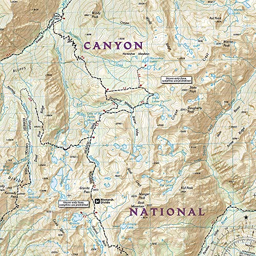
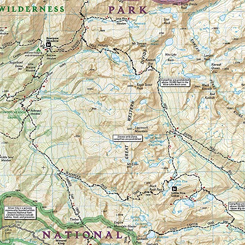
This is an okay map of Sequoia National Park and Kings Canyon national park.**It does NOT include anything south of Olancha and Kern Canyon. The Sequoia National Forest lands are not on this map, which is a little irritating, since it is all part of the same wilderness area.
S**R
Very good map
You won't get lost using this map. It saved me on a few washed out trails and some covered in snow. It is a bit complex (too complex) which is why I gave it 4 stars instead of 5, making it somewhat difficult to read. There is a lot of information that is not needed for a backpacker/ camper, etc.which makes reading it a bit confusing. I would recommend taping a magnifying glass to this map. It seems pretty waterproof as I used it in the snow with no issues. Folds up nicely also.
F**R
I own a ton of these maps!
National Geographic Trails is one of the best maps out there for those that orienteer the old school way. I worked at an outdoor store for years and these are ones I always recommended. I have hiked all over with them and have never had one tear or rip. They are easy to read and navigate, and I own one for every single place I have camped, hiked, hunted, or fished. Even with modern GPS, I always carry these maps and a compass as a back up.
S**N
Map review
This is a detailed map of the Sequoia / Kings Canyon area. If you have been to this beautiful part of the world, then this wipe clean map is a great reminder of your vacation..and of course of you plan to visit the area the map is an excellent companion. Try and rent a lodge and stay a few days to get the best out of the visit. I also have the National Geographical' map of Yosemite and Florida Everglades which are excellent quality too
A**S
Very useful map
Used the map to understand wher we would be going during our short trip to Sequoia.Will be holding on to it for when we return for a longer trip!
U**T
leider fehlt ein Teil, ansonsten sehr gut
Wir werden mehrere Tage im Sequoia-Kings Canyon NP verbringen und dafür ist die Karte super.Sie ist sehr genau, alles drauf.Wir haben Kinder und planen genau, was wir an welchem Tag machen und wo wir übernachten.Der Sequoia (südliche Teil) ist auf einer Seite der Karte, der Kings Canyon (nördliche Teil) auf der anderen Seite.Leider ist NUR der Park drauf d.h. wenn man vom Süden kommt, also zuerst den Sequoia durchfährt, muss man immer über Grant Grove Village fahren um in den nördlichen Teil, den Kings Canyon, zu kommen.Grant Grove Village ist noch auf der Karte. Aber auf der nördlichen Seite ist dann nur der Kings Canyon drauf d.h. es fehlt mir beim "Kings Canyon Scenic Byway" (den man machen muss!) die Strecke vom Grant Grove Village bis zum Park Eingang. Das ist sehr schade, denn da gibt es wohl tolle Aussichtspunkte und auch ein toller See (Hume Lake) zum Baden usw.Zum Glück gibt es dann Google Map / Google Earth.Aber ich denke eine bessere Karte gibt es nicht und ich war froh, ein so detaillierte Karte zu finden.
J**N
Gute Karte
Die Karte ist gut lesbar und enthält alle wichtigen Informationen. Ebenso hat sie den täglichen Einsatz auf einer mehrwöchigen Tour gut überstanden. Manchmal hatte ich Zweifel an der Genauigkeit, aber diese lassen/ließen sich nicht bestätigen.Der Maßstab ist zum wandern nicht ganz optimal, aber das war mir im Vorhinein klar und dafür kann die Karte auch nichts.
P**N
Übersichtliche Wanderkarte
Schöne und übersichtliche Wanderkarte. Gut geeignet zur Planung und für kleinere Wanderungen.
Trustpilot
2 months ago
4 days ago